
Solving Big GIS Projects on Desktop Computers
https://doi.org/10.32909/kg.18.32.4
Abstract
We are witnessing great developments in digital information technologies. The situation encroaches on spatial data, which contain both attributive and localization features, and this determines their position unequally within an obligatory coordinate system. These changes have resulted in the rapid growth of digital data, significantly supported by technical advances regarding the devices which produce them. As technology for making spatial data advances, methods and software for big data processing are falling behind. Paradoxically, only about 2% of the total volume of data is actually used (Čerba 2017). Big data processing often requires high computation performance hardware and software. Only a few users possess the appropriate information infrastructure. The proportion of processed data would improve if big data could be processed by ordinary users. In geographical information systems (GIS), these problems arise when solving projects related to extensive territory or considerable secondary complexity, which require big data processing.
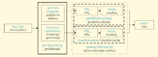
This paper focuses on the creation and verification of methods by which it would be possible to process effectively extensive projects in GIS supported by desktop hardware and software. It is a project regarding new quick methods for the functional reduction of the data volume, optimization of processing, edge detection in 3D and automated vectorization.
This paper focuses on the creation and verification of methods by which it would be possible to process effectively extensive projects in GIS supported by desktop hardware and software. It is a project regarding new quick methods for the functional reduction of the data volume, optimization of processing, edge detection in 3D and automated vectorization.
Keywords
geographic information system (GIS), big data, parallel computing; classification; optimization; filtration; point cloud
Copyright (c) 2019 Dalibor Bartoněk

This work is licensed under a Creative Commons Attribution-ShareAlike 4.0 International License.