Land Cover and Land Use in Slovakia within the LUCAS 201 5 Pan-European Harmonized Survey
Abstract
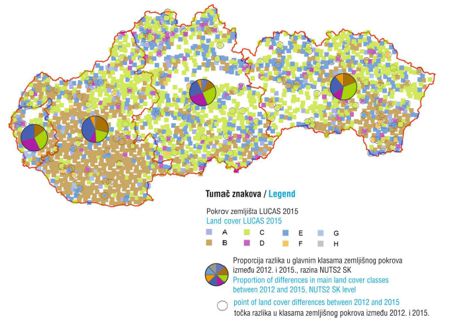
The LUCAS project was launched following a decision by the European Parliament and Council of the European Union in May 2000. Eurostat started the LUCAS pilot project in close cooperation with the technical support of the Directorate General for Agriculture and Rural Development’s Joint Research Centre in 2001 . The main aim of the project is to provide a common, aligned, in situ overview of agricultural and environmental data, using GNSS and photo documentation for specific, georeferenced points. Research was carried out in Slovakia over a three-year period, starting in 2006. In 2009, an evaluation of land cover/use was carried out. This article presents the process of preparing, securing, conducting and researching the management of land cover and land use in Slovakia. The survey was launched in 201 2. The classification base consists of eight categories of land cover and land use, which are broken down into more detail. The result is a structured database of images and digital records for 2,455 selected points. The largest class mapped is forestland. The stabilization of the sampling scheme allowed the construction of a time series for monitoring land cover changes for selected types.
Keywords
Copyright (c) 2016 Vladimír Hutár, Peter Koleda, Michal Sviček, František Petrovič, Zlatica Muchova, Mária Leitmanová

This work is licensed under a Creative Commons Attribution-ShareAlike 4.0 International License.