
Original Scientific Paper
A Low-Distortion Map of the World Ocean Without Discontinuities
https://doi.org/10.32909/kg.21.si.6
Abstract
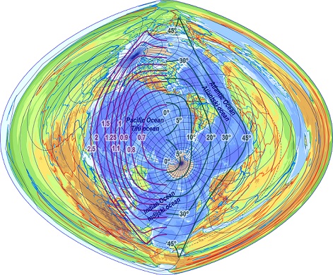
Ocean maps are rarely in the scope of current studies on minimum-distortion map projec-tions. This study aims to create an uninterrupted map projection to display planet Earth as the Blue Planet: the aspect of the projection is rotated into the middle of the water surface; favourable map distortions are optimized numerically across the World Ocean. The paper starts with a short overview of existing similar projections. In the next pages, the reader may find the detailed description on the development of the new mapping. The paper concludes with maps and distortion analysis in the proposed projection and thoughts about its potential usefulness.
Keywords
World Ocean; Optimal map projections; Numerical optimization
Copyright (c) 2023 Krisztián Kerkovits

This work is licensed under a Creative Commons Attribution-ShareAlike 4.0 International License.