
Structural Characteristics of Patches in the Central Lika Landscape – Application of Spatial and Regression Analysis
https://doi.org/10.32909/kg.19.34.2
Abstract
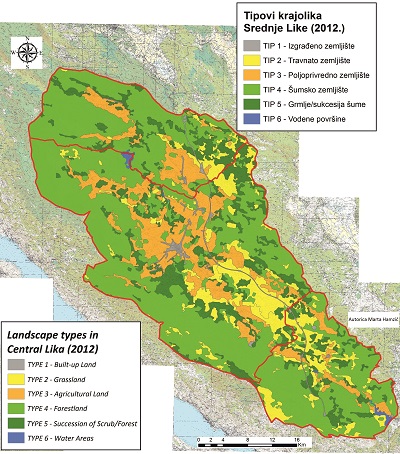
This paper analyses the structural characteristics (shape, position and condition) of landscape patches in Central Lika according to landscape types and for the landscape of Central Lika as a whole. A set of indicators for the landscape structure was used along with GIS technology. Interrelation of the structural characteristics of landscape patches were determined using regression analysis. When determining the landscape types of Central Lika, a method based on land cover/land use was applied. For this purpose, data from the CORINE database for the year 2012 were used. At the level of the landscape type in Central Lika and the landscape of Central Lika as a whole, a set of indicators for the landscape structure were used, based on a variety of spatial analysis methods: Mean Shape Index – for the landscape patch shapes; Core Area Index – for the condition of the landscape patches, and Average Nearest Neighbour – for the position of the landscape patches. The most important result of this paper was to confirm the correlation between the shape and condition, and between the shape and position of the landscape patches of Central Lika, while no correlation between the condition and position of the landscape patches of Central Lika was found.
Keywords
Land cover/land use; structural characteristics; landscape patches; GIS; regression analysis; spatial analysis; Central Lika
Copyright (c) 2020 Marta Hamzić, Born Fuerst-Bjeliš, Mladen Pahernik

This work is licensed under a Creative Commons Attribution-ShareAlike 4.0 International License.