Panta Rhei: Movement Change of Tschadinhorn Rock Glacier (Hohe Tauern Range, Austria), 1954–2017
https://doi.org/10.32909/kg.18.31.1
Abstract
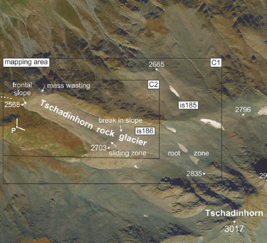
In this paper we present a reconstruction of the kinematics of the Tschadinhorn rock glacier using multi-temporal conventional (metric) aerial photographs (1954–2015) and additional non-metric aerial photographs (2016, 2017) taken with in-house unmanned aerial vehicles (UAVs). A rotary-wing aircraft (hexacopter twinHEX v.3.0) was used in 2016 and a fixed-wing aircraft (QuestUAV) in 2017. The historical image data was acquired from the Austrian Federal Office of Metrology and Surveying (BEV). Both a digital orthophoto (DOP) and a digital terrain model (DTM) were computed for each given epoch. Precise georeferencing of the image data was carried out in the Austrian Gauss-Krüger M31 coordinate system using available aerotriangulations (ATs) of BEV and additional ground control points (GCPs) measured geodetically during both UAV campaigns. Change detection analysis provided multi-temporal 2D flow velocity fields. Subsequently, these data were collated to produce a simpler velocity graph showing clearly the temporal evolution of the flow velocity of Tschadinhorn rock glacier: A maximum mean annual flow velocity of 3.28 m/year was obtained for 2014–2015, while the lowest annual flow velocity of 0.16 m/year was observed for 1969–1974. The velocity graph also revealed that 1954–2009 was characterized by generally moderate activity (0.16 – 0.79 m/year) and that much higher flow velocities have prevailed since 2009. The present value for 2016–2017 is 1.92 m/year.
Keywords
permafrost; rock glacier; flow velocity; photogrammetry; UAV; environmental change; Tschadinhorn
Copyright (c) 2019 Viktor Kaufmann, Wolfgang Sulzer, Gernot Seier, Matthias Wecht

This work is licensed under a Creative Commons Attribution-ShareAlike 4.0 International License.