Cover Image

The Novi Vinodol Astronomic and Trigonometric Point

Miljenko Lapaine

Abstract


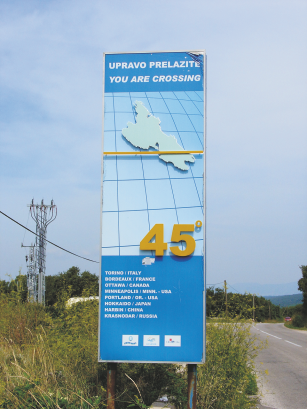
The paper gives a historical account of how the Novi Vinodol astronomic point was created – a point which has been maintained until the present day as a second class trigonometric point. It is the end point of a chain of triangles set up in the early 20th century to establish the halfway parallel, i.e. the parallel corresponding to 45° latitude. The geometric and astronomic works were conceived and led by General Stevan P. Bošković, Director of the Military-Geographic Institute in Belgrade.

Keywords


Novi Vinodol; astronomic point; trigonometric point; Military-Geographic Institute

Full Text:

PDF PDF (Hrvatski)


Copyright (c) 2018 Miljenko Lapaine

Creative Commons License
This work is licensed under a Creative Commons Attribution-ShareAlike 4.0 International License.


The Kartografija i Geoinformacije (Cartography and Geoinformation) journal publishes scientific and professional papers from cartography and other fields (geography, geodesy, geology, forestry, agronomy, history, architecture, pedagogy ...) if they are related to cartography and geoinformation.
We invite authors of papers or contributions to submit text in English (and Croatian if possible) using this site.

The Croatian Cartographic Society (CCS) does not necessarily endorse any opinions or recommendations made in article, review or extract contained in this journal nor do they necessarily represent CCS policy.
© CCS, www.kartografija.hr. Journal content is published under CC BY-SA licence.