Historical Maps of Varaždin from 16th to 19th Century, A lecture by Miroslav Klemm, 30th September 2010, Herczer Palace, Town Museum Varaždin
Mirko Husak
Abstract
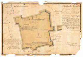
Historical society of the city of Varaždin and Varaždin County organizes regular lectures on the last Tuesday in a month. After summer pause, on Thursday evening, beginning at 7 p.m., on 30th September 2010, at the Herczer Palace of the Town Museum Varaždin in Varaždin, Franjevački trg 6, Miroslav Klemm had a lecture: Historical maps of Varaždin from 16th to 19th century.
Copyright (c) 2013 Mirko Husak

This work is licensed under a
Creative Commons Attribution-ShareAlike 4.0 International License.
The Kartografija i Geoinformacije (Cartography and Geoinformation) journal publishes scientific and professional papers from cartography and other fields (geography, geodesy, geology, forestry, agronomy, history, architecture, pedagogy ...) if they are related to cartography and geoinformation.
We invite authors of papers or contributions to submit text in English (and Croatian if possible) using this site.
The Croatian Cartographic Society (CCS) does not necessarily endorse any opinions or recommendations made in article, review or extract contained in this journal nor do they necessarily represent CCS policy.
© CCS, www.kartografija.hr. Journal content is published under CC BY-SA licence.