
Original Scientific Paper
Manuscript Map of Illyricum, 1663, in the Pontifical Croatian College of St Jerome: a Supplement to Previous Knowledge
https://doi.org/10.32909/kg.21.si.3
Abstract
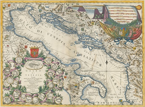
In the Pontifical Croatian College of St. Jerome in Rome, a manuscript geographic map of Illyricum is kept, drawn in 1663 by the architect and geographer, Pietro Andrea Buffalini of Rome. Cartographic analysis of this map has been carried out on several occasions, and the ecclesiastico-legal and historico-geographic context of its origin analysed. As contribution to previous research on the 1663 map of Illyricum, the depiction of the coast on that map is cartometrically compared with that on geographic maps and nautical charts from the late 16th century and the first half of the 17th. On the basis of these analyses it is confirmed that, with the 1663 map of Illyricum, a qualitative step forward was taken in depicting the northeast coast of the Adriatic. In addition, on the basis of research into available written data sources, it is concluded that Ivan Lučić made a key (co)authorial contribution to the shaping of the geographic content of this manuscript map.
Keywords
geography; cartography; map; Illyricum; Ivan Lučić; Stjepan Gradić; Pietro Andrea Buffalini; Pontifical Croatian College of St Jerome; Croatia
Copyright (c) 2023 Josip Faričić, Tome Marelić, Zdenko Dundović

This work is licensed under a Creative Commons Attribution-ShareAlike 4.0 International License.