Cover Image

Google Maps State of the Art of the Online Road Map

Dražen Tutić, Nedjeljko Frančula

Abstract


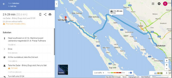
The primary use of Google Maps is navigation on land and finding a route for travelling by car, public transport, bike, airplane or on foot. It is hard to find a tool better suited for these tasks than Google Maps. When travelling by car is considered, the application provides one or more routes, each with corresponding length in km or miles and time needed to reach the destination. The recommended route is given coloured blue, while others are grey. For public transport routes, e.g. in Zagreb, it lists numbers of tram and bus lines and travelling time.

Keywords


Google maps, road map

Full Text:

PDF PDF (Hrvatski)


Copyright (c) 2016 Dražen Tutić, Nedjeljko Frančula

Creative Commons License
This work is licensed under a Creative Commons Attribution-ShareAlike 4.0 International License.


The Kartografija i Geoinformacije (Cartography and Geoinformation) journal publishes scientific and professional papers from cartography and other fields (geography, geodesy, geology, forestry, agronomy, history, architecture, pedagogy ...) if they are related to cartography and geoinformation.
We invite authors of papers or contributions to submit text in English (and Croatian if possible) using this site.

The Croatian Cartographic Society (CCS) does not necessarily endorse any opinions or recommendations made in article, review or extract contained in this journal nor do they necessarily represent CCS policy.
© CCS, www.kartografija.hr. Journal content is published under CC BY-SA licence.