The Cartographic Opus of Ferdinand Konšcak
Abstract
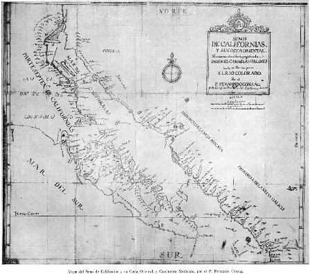
The Jesuit Ferdinand Konšćak (1703–1759) from Varaždin was a Croatian explorer, missionary and cartographer in the Lower California area. Konšćak’s maps were published in 1757 in a work by Miguel Venegas and Marcos Buriel, Noticia de la California. The book appeared in Spanish, and later in English (1759), Dutch (1761/2), French (1766 and 1796/7) and German. In this paper, all the maps attributed to Ferdinand Konšćak are listed and presented for the first time, while the reproductions are taken from the highest quality editions. The places throughout the world where Konšćak’s maps are kept are also listed. In a separate table, the most important information regarding the maps presented in this paper is given in overview. Finally, it is concluded that the life and work of Ferdinand Konšćak have been insufficiently researched, particularly in regard to his cartographic contributions.
Keywords
Ferdinand Konšćak, cartography, Lower California
Copyright (c) 2016 Mirko Husak

This work is licensed under a Creative Commons Attribution-ShareAlike 4.0 International License.