The Representation of the Hungarian Towns in Domenico Zenoi's and Paolo Forlani's Cartographic Work
Abstract
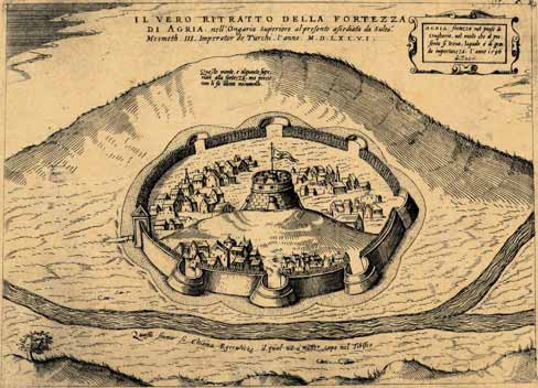
In the mid-16th century Venice was the European center of cartography. The two most distinguished representatives of the Venetian school of cartography, which included their close collaborators, Natale Bonifacio and Martin Rota Kolunic from Šibenik in Dalmatia, were Domenico Zenoi and Paolo Forlani. The study deals with their cartographic and publishing activity, their relationship and rivalry within the context of the Venetian cartographic production and analyzes in detail their engravings of the Hungarian towns at the time of the Ottoman conquests, including the siege and the fall of the fortress Sziget during the command of Nikola Šubić Zrinyi. The analysis is based on the five extant copies of Zenoi's and Forlani's collections of views, two of which have been unknown until discovered by the author in the Budapest National Library.
Keywords: Cartography; Venice; Zenoi; Forlani; Hungarian towns; Ottoman conquests
Copyright (c) 2013 Béla Szalai

This work is licensed under a Creative Commons Attribution-ShareAlike 4.0 International License.