
Integrated Multi-Level Assessment of Regional Development Sustainability and Mapping
https://doi.org/10.32909/kg.17.29.2
Abstract
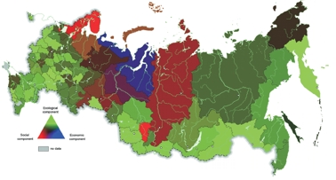
This article describes a method for the complex assessment of the sustainable development of territories based on social development, economic development and ecological situation indices. The method allows an analysis of the comprehensive, sustainable development of territories, and at the same time details elements of the problem detected by the successive hierarchical decomposition of the aggregated indices. It takes into account the peculiarities of non-homogeneous regions and those which are difficult to compare. Their evaluation using conventional methods of identification and typology does not produce the most rapid, effective, or objective results. The Russian Federation was used an example to test the methodology. The potential analysis of sustainable development was supplemented with a map created according to the colour triangle method, which allows the balance of components to be visualized at each level analysed. The theoretical principles considered and their practical use helped complete an assessment of the basic parameters of sustainable development in the Russian regions. Based on this, it was possible to form a unified list of criteria which might become the national standard for assessing sustainable development at the local, regional and federal levels, and recommended for practical use in the development and adoption of new regional solutions.
Keywords
sustainable development, index, Russian Federation regions, social development, economic development, environmental stress
Copyright (c) 2018 Vladimir Tikunov

This work is licensed under a Creative Commons Attribution-ShareAlike 4.0 International License.