Surveying the Vienna Meridian from Brno to Varaždin
Abstract
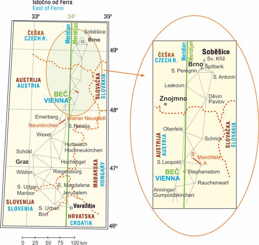
The introduction provides a brief overview of using trigonometric chains for determining meridian arc lengths in Europe, as well as their extension to trigonometric networks in order to produce contemporary accurate maps in France. After Ruđer Bošković had visited Croatian-Hungarian Queen and Roman-German Empress Maria Theresa, she ordered Jesuit Joseph Liesganig to survey the meridian from Brno (Soběšice), over Vienna and Graz to Varaždin by establishing and surveying a trigonometric chain. That distance amounts to 320 km, i.e. the difference between latitude of the starting and finishing points of the chain equaled 2° 56' 45.85''. Two baselines were measured directly between Wiener Neustadt and Neunkirchen of 6410.903 Vienna fathom (12 158.175 m) and between Seyring and Glizendorf in the Moravian field (Moravské pole, Marchfeld) of 6387.862 Vienna fathom (12 114.478 m). Liesganig published previous Vienna Meridian survey results in Philosophical Transactions in London in 1768 and the final results in Latin in Dimensio Graduum Meridiani Viennensis et Hungarici in 1770. His results were quickly criticized and subsequently subjected to validation. Trigonometric point Varaždin is the first and oldest trigonometric point in Croatia.
Keywords
meridian arc survey, trigonometric chain, Vienna Meridian, zenith sector, quadrant
Copyright (c) 2016 Miljenko Solarić, Nikola Solarić

This work is licensed under a Creative Commons Attribution-ShareAlike 4.0 International License.