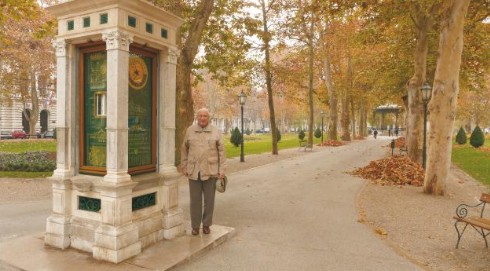
Analysis of Geographic Coordinates of the Meteorological Post at Zrinjevac
Abstract
The Meteorological Post at Zrinjevac built in 1884 is a public meteorological station where many citizens and visitors can obtain information about temperature, humidity and air pressure in the centre of the town. Based on the available documentation, the paper presents the analysis of geographic coordinates of the post, their reliability (accuracy) – referring to whether they determine the real position of the post and who and when determined them. There are also the analysed coordinates given that were established by Ivan Stožir in 1884, then the coordinates read by Guro Pila in 1890 from the new special map of Austro-Hungarian Monarchy and converted in 1941 by Nikolaj Abakumov from rectangular coordinates from the cadastral plan, and finally, the coordinates determined by means of modern GNSS measuring systems. There are also the changes of the form and the contents of the post show window described that took place on the occasion of two great restorations in 1959 and 1993 and were done in accordance with its modernisation. The clock with the 24-hour dial is also described. The times of sunrise and sunset in Zagreb have been checked and recalculated.
Keywords
meteorological post, Zrinjevac, geographic coordinates, clock, 24-hour clock face, sunrise and sunset time
Copyright (c) 2016 Drago Špoljarić, Božidar Kanajet

This work is licensed under a Creative Commons Attribution-ShareAlike 4.0 International License.
