500th Anniversary of Gerard Mercator's Birth
Abstract
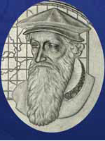
Mercator was a geographer, mathematician, astronomer, globe producer, constructor of scientific instruments, copper engraver, cartographer, surveryor and publisher. The conformal cylindrical projection was named the Mercator projection after him. The normal aspect Mercator projection is especially important in navigation because rhumb lines are mapped as straight lines in that projection. The transverse Mercator projection is used in official cartography of many countries. The Universal Transverse Mercator (UTM) projection is in military use (NATO). In addition, Mercator was the first to use the term atlas for a map collection.
Copyright (c) 2013 Ivka Kljajić

This work is licensed under a Creative Commons Attribution-ShareAlike 4.0 International License.