Cover Image

Exhibition Opatija Riviera on Plans and Maps, Opatija, November 25–27, 2010

Ivka Kljajić

Abstract


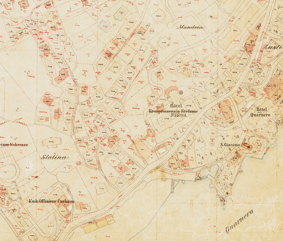
The exhibition Opatija Riviera on Plans and Maps was prepared within the 2nd Croatian NSDI and INSPIRE Day and the 6th Cartography and Geoinformation Conference. The exhibition was organised by the Croatian Cartographic Society, and the co-organizers were the Head Office and the Branch Office Opatija of the Regional Cadastral Office Rijeka of the State Geodetic Administration. The exhibition was set in the Congress Centre Tamaris of the Milenij Grand Hotel 4 opatijska cvijeta in Opatija, and it could be seen on November 25–26, 2010.

Full Text:

PDF PDF (Hrvatski)


Copyright (c) 2013 Ivka Kljajić

Creative Commons License
This work is licensed under a Creative Commons Attribution-ShareAlike 4.0 International License.


The Kartografija i Geoinformacije (Cartography and Geoinformation) journal publishes scientific and professional papers from cartography and other fields (geography, geodesy, geology, forestry, agronomy, history, architecture, pedagogy ...) if they are related to cartography and geoinformation.
We invite authors of papers or contributions to submit text in English (and Croatian if possible) using this site.

The Croatian Cartographic Society (CCS) does not necessarily endorse any opinions or recommendations made in article, review or extract contained in this journal nor do they necessarily represent CCS policy.
© CCS, www.kartografija.hr. Journal content is published under CC BY-SA licence.