Disaster management circular chart

The Role of Geoinformation in Disaster Management

Sonja Dimova

Abstract


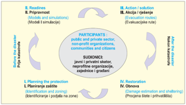
Various disasters which occur often can be catastrophic to mankind. The development of technology enables geodesy and geoinformation to actively participate in the process of disaster management. Geoinformation are the basis for planning, monitoring and evacuating population in the process of disaster management. This paper has the objective to emphasize the role of geodesy and especially geoinformation in applying the process of disaster management.

Keywords


disasters; geoinformation; disaster management; quality of geoinformation; GIS; NSDI

Full Text:

PDF PDF (Hrvatski)


Copyright (c) 2013 Sonja Dimova

Creative Commons License
This work is licensed under a Creative Commons Attribution-ShareAlike 4.0 International License.


The Kartografija i Geoinformacije (Cartography and Geoinformation) journal publishes scientific and professional papers from cartography and other fields (geography, geodesy, geology, forestry, agronomy, history, architecture, pedagogy ...) if they are related to cartography and geoinformation.
We invite authors of papers or contributions to submit text in English (and Croatian if possible) using this site.

The Croatian Cartographic Society (CCS) does not necessarily endorse any opinions or recommendations made in article, review or extract contained in this journal nor do they necessarily represent CCS policy.
© CCS, www.kartografija.hr. Journal content is published under CC BY-SA licence.