Eurocodes

About Maps Enclosed with Eurocodes

Marina Rajaković

Abstract


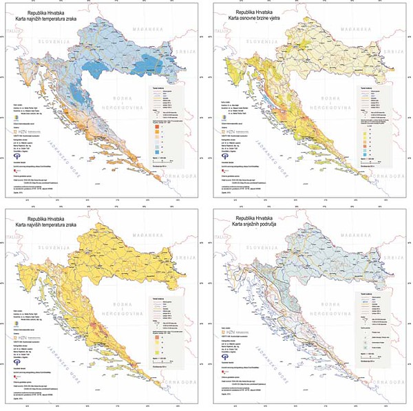
By accepting European norms for construction design, Croatia also accepted the principle of embedding national specificities, primarily referring to natural phenomena (wind, earthquake, snow, temperature) into eachstandard, i.e. to create special annexes for a certain norm with defined national parameters.

In accordance with these standards, the Croatian Standards Institute (Hrvatski zavod za norme – HZN) ordered from the Faculty of Geodesy in Zagreb a cartographic map processing of snow areas, the lowest and highest air temperatures and basic wind speeds for the territory of the Republic of Croatia.


Full Text:

PDF PDF (Hrvatski)


Copyright (c) 2013 Marina Rajaković

Creative Commons License
This work is licensed under a Creative Commons Attribution-ShareAlike 4.0 International License.


The Kartografija i Geoinformacije (Cartography and Geoinformation) journal publishes scientific and professional papers from cartography and other fields (geography, geodesy, geology, forestry, agronomy, history, architecture, pedagogy ...) if they are related to cartography and geoinformation.
We invite authors of papers or contributions to submit text in English (and Croatian if possible) using this site.

The Croatian Cartographic Society (CCS) does not necessarily endorse any opinions or recommendations made in article, review or extract contained in this journal nor do they necessarily represent CCS policy.
© CCS, www.kartografija.hr. Journal content is published under CC BY-SA licence.