Production of Digital Orthophoto Maps at the Scale of 1:5000 (DOP5) for the Entire Territory of the Republic of Croatia
Ivan Landek
Abstract
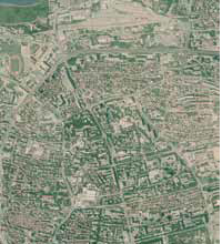
Pursuant to the Law on the Treatment of Illegally Built Constructions (OG 90/11), the State Geodetic Administration has been charged with producing a digital orthophoto map at the scale of 1:5000 (DOP5) for the entire territory of the Republic of Croatia.
Copyright (c) 2012 Ivan Landek

This work is licensed under a
Creative Commons Attribution-ShareAlike 4.0 International License.
The Kartografija i Geoinformacije (Cartography and Geoinformation) journal publishes scientific and professional papers from cartography and other fields (geography, geodesy, geology, forestry, agronomy, history, architecture, pedagogy ...) if they are related to cartography and geoinformation.
We invite authors of papers or contributions to submit text in English (and Croatian if possible) using this site.
The Croatian Cartographic Society (CCS) does not necessarily endorse any opinions or recommendations made in article, review or extract contained in this journal nor do they necessarily represent CCS policy.
© CCS, www.kartografija.hr. Journal content is published under CC BY-SA licence.